As we traveled the Kittiwake Coast, we drove thru Terra Nova National Park. This park protects approximately 250 square miles of boreal forest and scenic coastline. Boating, kayaking, and hiking are the predominant sports of this area. The Visitor Information Marine Centre has exciting marine exhibits to help visitors explore the local marine environment – aquariums, a  touch tank, underwater camera and more.
Our next stop was in Boyd’s Cove where an interpretation center, trail and archaeological site provide a picture of native life. The Beothuks chose Boyd’s Cove for a number of reasons. The site has a good beach upon which to draw up canoes and Indian Brook, which enters the sea just below the site, is a good source of fresh water. The site is located on top of a glacial moraine with sand and gravel. When it rained, the site quickly drained thru the glacial silt, keeping it dry. Smelt come in large number each year to spawn and from the tiny smelt bones recovered at the site, it is known that it was a favorite food of the Beothuk. Believed to live at Boyd’s Cove between 1650 and 1720, the Beothuks were a hunting and fishing people. They avoided trade with the European fishermen who were there in the Spring and left in the Fall. Once they had left, the Beothuks would visit the fishing premises and pick up nails, fish hooks and other objects lost and abandoned by the fishermen and rework them for their own uses.
The Beothuks dug large, shallow pits into the ground and erected sturdy bark-covered wigwams in them. The archaelogists have found the remains of eleven of these warm, comfortable dwellings. Once the Europeans began living full time in the Cove, the Beothuks were pushed into the interior away from their coastal hunting and fishing grounds. Many bloody encounters between the settlers and the Beothuk were recorded in the early 1700s and 1800s. In June, 1829, the last Beothuk, Shanawdithit, died in St. Johns.
Located along the trail that leads from the Interpretation Center to the archaelogical site are interpretive panels which deal with the relationship between the Beothuk and their natural environment. McKenzie was anxious to get on her way down the trail!
Along the trail, we spotted beautiful colored mushrooms and McKenzie enjoyed tracking
 and leading us to the bronze statue created by Newfoundland artist, Gerald Squires and entitled,
 “The Spirit of Beothuk”. Squires portrayed Shanawdithit with her vulnerability and strength as well as her torment and tenderness.
At the end of the “Road to the Isles” is the historic community of Twillingate. Most people flock to this area to explore its history and discover the mighty icebergs, whales, and birds up close on one of the boat tours. When we arrived there, the wind was blowing in gusts of 40 to 50 mph. and no boats were going out. However, since it was the end of the season, we would probably not have seen whales and certainly not icebergs anyway. We did drive up to Long Point Lighthouse which sits a commanding 300 feet above sea level. The viewing platform overlooks the famous “iceberg alley”
  where each Spring, hundreds of icebergs, most weighing between 100 and 200 thousand tons, carve a path through the ocean. We can just imagine how breathtaking it would be to experience that view. We were overwhelmed with the view even without the icebergs.
 George and I followed the pathways around the cliffs
  and kept our eyes peeled for whales.
  The wind finally got the better of us and we decided we’d had enough for the day.
Crows Head is a little village outside Twillingate and we were lucky enough to be able to get reservations to the last performance for the year at the “All Around the Circle Dinner Theatre”. This is a group of seven Newfoundlanders who entertain with singing, dancing, musical instruments and comedy. In addition, they also prepare a traditional Newfoundland dinner consisting of homemade vegetable beef soup, pan-fried cod, mashed potatoes, glazed carrots, homemade bread roll, dessert and tea or coffee. They entertained about 40 of us for a good hour and a half and each of them was extremely talented!
The next morning we awoke to 56 degrees and more wind than yesterday, mixed with rain. We decided it was definitely time to get off the tip of this peninsula and to start on our inland trip. But before we left Twillingate, we paid a visit to the Auk Island Winery which touts that they are the “only winery in the world that makes fine wines using iceberg water”. They also make their wines out of berries found on the island, so we bought a bottle to try.
Our trail now led us over to Gander which is the hub for the Kittiwake Coast. Known as “the Crossroads of the World”, Gander gained its fame from its international airport, conveniently located about halfway between the major metropolitan areas of North America and Europe. The airfield was constructed during the wartime because of its inland location and the region’s reputation for being fog-free.
The Silent Witnesses Memorial, located along the Trans Canada Highway, is dedicated to those who perished in the 1985 Arrow Air crash. On December 11, 1985, Arrow Air Flight MF1285R departed Cairo, Egypt on an international charter flight to Fort Campbell, Kentucky via Cologne, Germany and Gander, Newfoundland. On board were 8 crew and 248 passengers. The flight had been chartered to transport troops, their personal effects, and some military equipment from peacekeeping duties in the Sinai desert. All 248 passengers were members of the 101st Airborne Division (U.S. Army), based at Fort Campbell. The flight departed Cairo and arrived at Cologne on December 11, 1985 for a planned technical stop. A complete crew change took place following which the flight departed for Gander at 11:20 p.m. The flight arrived at Gander at 5:34 a.m. where passengers were deplaned and the aircraft refueled and serviced. The flight departed Gander at 6:45 a.m. The aircraft gained little altitude after rotation and began to descend crossing the Trans Canada Highway, approximately 900 feet beyond the departure end of the runway. The aircraft continued to descend until it struck downsloping terrain approximately 3,000 feet beyond the departure end of the runway. The aircraft was destroyed by impact forces and severe fuel-fed fires. All 256 occupants on board sustained fatal injuries. The accident occurred at 6:46 a.m. during the hours of darkness and was the worst air disaster ever on Canadian soil.
On June 24, 1990, a dedication ceremony was held in memory of the 101st Airborne Division. This memorial depicts an unarmed American soldier standing atop a massive rock holding the hands of two children. The children, a boy and a girl, each hold an olive branch indicative of the peacekeeping mission of the 101st Airborne Division “Screaming Eagles” on the Sinai peninsula. Behind them rise three tall staffs, each bearing a flag, Canada, U.S., and Newfoundland. As the trio stands looking into the future, they are surrounded by the trees, hills, and rocks of the actual Arrow Air crash site, overlooking Gander Lake in the direction of Fort Campbell. The natural surroundings are the “Silent Witnesses” of the precise moment when 256 dreams ended and the hearts and imaginations of an entire world were captured.
Down the hill from the memorial is the “Cross of Sacrifice” which is 22 feet in height. The inscription “Rendezvous with Destiny”, the motto of the 101st Airborne Division is inscribed on the remains of the emergency exit door of the ill-fated DC-8. Surrounding the cross are planted 256 native trees as a tribute to each of the crash victims.
Gander was again in the news 16 years after this tragedy when on September 11, 2001, the world was shocked by unexpected acts of terrorism in the United States. Within minutes, the airspace over North America was shut down and many aircrafts were forced to land as soon as possible. At Gander International airport, 39 international aircraft landed and the town of Gander, along with nearby communities such as Appleton, Gambo, Glenwood, and Lewisporte, played host to more than 6,500 unexpected visitors. The town provided meals, necessary supplies, and places to sleep until the planes were once again allowed in the air.
The next morning we headed further into the interior of Newfoundland. It is definitely not as scenic being on the Trans Canada (Rt. #1) highway, but it is the only way over to the west coast. As you can see, you would see very little if you just stayed on the Trans Can all the way across the island. We made a brief detour at Bishop Falls to take a small hike to the Bishop Falls Trestle. This is a former railway trestle, now a boardwalk that spans 927 feet across the Exploits River. The steel and granite structure was built in 1901 and is the longest trestle in
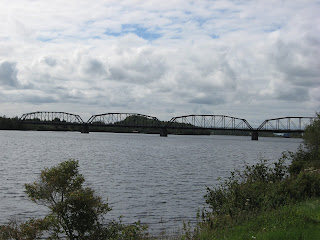 Newfoundland. Since we had an absolutely gorgeous, sunny, wind-free day, it was a nice deviation to walk across it and look at the peaceful, flowing river.
 On the way back, we spotted this unusual decorated tree. You never know who is watching you.
Our last stop for the day was at Grand Falls-Windsor and the Loggers Life Provincial Museum. The museum recreates life at a typical 1930’s depression era logging camp.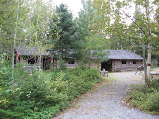 It would have normally housed 25-30 men who worked cutting timber for paper mills. They normally were paid $.90 per cord of wood and the normal logger could cut an average of two cords a day. As if this wasn’t bad enough, they had to pay $25.00 a month out of their pay for room and board. For this they received three meals a day and a wooden bunk. They would chop fir boughs to lay on top of the bunks to help keep them warm and reduce the hardness of the wood.
 Many of them were fishermen looking for extra money to feed their families and might have walked for days before arriving at the camp, hoping to get hired. They worked long days in boggy, wet land, with very strict rules to live by. Sometimes there were two men to a bunk, but always they had their fill of food, However they were not allowed to talk in the dining room at meal time in order to facilitate getting everyone served quickly.
 The times were hard, the pay was poor but to many, it was the only chance their family, which they had left back at home, had at surviving. In later years, the logging companies built the company town of Grand Falls and many of the loggers brought their families to live here where the company provided a school for the children, a store for supplies, and homes for the workers. If you did not work for the logging company, you could not live in the town of Grand Falls, so those who were not working for the logging company, settled outside the city and that area became knows as Windsor. Gradually both towns joined together as one and as the introduction of power saws meant fewer men could cut more wood, companies employed smaller workforces and the logging industry declined.
Tomorrow will find us trying to find a laundry and probably visiting one more museum here in Grand Falls-Windsor and then we’ll be on our way over to Gros Morne National Park on the western shore of Newfoundland. The weather is starting to get a little cooler but we are still having some very beautiful sunny days. I think both of us are ready to get back over to the coast though and get out of the forests. Who knows what we will see next, but it has surely been exciting. Hope you’ll stay with us for the rest of the trip!
touch tank, underwater camera and more.Our next stop was in Boyd’s Cove where an interpretation center, trail and archaeological site provide a picture of native life.
The Beothuks chose Boyd’s Cove for a number of reasons. The site has a good beach upon which to draw up canoes and Indian Brook, which enters the sea just below the site, is a good source of fresh water. The site is located on top of a glacial moraine with sand and gravel. When it rained, the site quickly drained thru the glacial silt, keeping it dry. Smelt come in large number each year to spawn and from the tiny smelt bones recovered at the site, it is known that it was a favorite food of the Beothuk. Believed to live at Boyd’s Cove between 1650 and 1720, the Beothuks were a hunting and fishing people. They avoided trade with the European fishermen who were there in the Spring and left in the Fall. Once they had left, the Beothuks would visit the fishing premises and pick up nails, fish hooks and other objects lost and abandoned by the fishermen and rework them for their own uses.The Beothuks dug large, shallow pits into the ground and erected sturdy bark-covered wigwams in them. The archaelogists have found the remains of eleven of these warm, comfortable dwellings.
Once the Europeans began living full time in the Cove, the Beothuks were pushed into the interior away from their coastal hunting and fishing grounds. Many bloody encounters between the settlers and the Beothuk were recorded in the early 1700s and 1800s. In June, 1829, the last Beothuk, Shanawdithit, died in St. Johns.Located along the trail that leads from the Interpretation Center to the archaelogical site are interpretive panels which deal with the relationship between the Beothuk and their natural environment. McKenzie was anxious to get on her way down the trail!
Along the trail, we spotted beautiful colored mushrooms
and McKenzie enjoyed tracking and leading us to the bronze statue created by Newfoundland artist, Gerald Squires and entitled, “The Spirit of Beothuk”. Squires portrayed Shanawdithit with her vulnerability and strength as well as her torment and tenderness.At the end of the “Road to the Isles” is the historic community of Twillingate. Most people flock to this area to explore its history and discover the mighty icebergs, whales, and birds up close on one of the boat tours. When we arrived there, the wind was blowing in gusts of 40 to 50 mph. and no boats were going out. However, since it was the end of the season, we would probably not have seen whales and certainly not icebergs anyway. We did drive up to Long Point Lighthouse
which sits a commanding 300 feet above sea level. The viewing platform overlooks the famous “iceberg alley” where each Spring, hundreds of icebergs, most weighing between 100 and 200 thousand tons, carve a path through the ocean. We can just imagine how breathtaking it would be to experience that view. We were overwhelmed with the view even without the icebergs. George and I followed the pathways around the cliffs and kept our eyes peeled for whales. The wind finally got the better of us and we decided we’d had enough for the day. Crows Head is a little village outside Twillingate and we were lucky enough to be able to get reservations to the last performance for the year at the “All Around the Circle Dinner Theatre”.
This is a group of seven Newfoundlanders who entertain with singing, dancing, musical instruments and comedy. In addition, they also prepare a traditional Newfoundland dinner consisting of homemade vegetable beef soup, pan-fried cod, mashed potatoes, glazed carrots, homemade bread roll, dessert and tea or coffee. They entertained about 40 of us for a good hour and a half and each of them was extremely talented!The next morning we awoke to 56 degrees and more wind than yesterday, mixed with rain. We decided it was definitely time to get off the tip of this peninsula and to start on our inland trip. But before we left Twillingate, we paid a visit to the Auk Island Winery which touts that they are the “only winery in the world that makes fine wines using iceberg water”. They also make their wines out of berries found on the island, so we bought a bottle to try.
Our trail now led us over to Gander which is the hub for the Kittiwake Coast. Known as “the Crossroads of the World”, Gander gained its fame from its international airport, conveniently located about halfway between the major metropolitan areas of North America and Europe. The airfield was constructed during the wartime because of its inland location and the region’s reputation for being fog-free.
The Silent Witnesses Memorial, located along the Trans Canada Highway, is dedicated to those
who perished in the 1985 Arrow Air crash. On December 11, 1985, Arrow Air Flight MF1285R departed Cairo, Egypt on an international charter flight to Fort Campbell, Kentucky via Cologne, Germany and Gander, Newfoundland. On board were 8 crew and 248 passengers. The flight had been chartered to transport troops, their personal effects, and some military equipment from peacekeeping duties in the Sinai desert. All 248 passengers were members of the 101st Airborne Division (U.S. Army), based at Fort Campbell. The flight departed Cairo and arrived at Cologne on December 11, 1985 for a planned technical stop. A complete crew change took place following which the flight departed for Gander at 11:20 p.m. The flight arrived at Gander at 5:34 a.m. where passengers were deplaned and the aircraft refueled and serviced. The flight departed Gander at 6:45 a.m. The aircraft gained little altitude after rotation and began to descend crossing the Trans Canada Highway, approximately 900 feet beyond the departure end of the runway. The aircraft continued to descend until it struck downsloping terrain approximately 3,000 feet beyond the departure end of the runway. The aircraft was destroyed by impact forces and severe fuel-fed fires. All 256 occupants on board sustained fatal injuries. The accident occurred at 6:46 a.m. during the hours of darkness and was the worst air disaster ever on Canadian soil.On June 24, 1990, a dedication ceremony was held in memory of the 101st Airborne Division. This memorial depicts an unarmed American soldier standing atop a massive rock holding the hands of two children. The children, a boy and a girl, each hold an olive branch indicative of the peacekeeping mission of the 101st Airborne Division “Screaming Eagles” on the Sinai peninsula. Behind them rise three tall staffs, each bearing a flag, Canada, U.S., and Newfoundland. As the trio stands looking into the future, they are surrounded by the trees, hills, and rocks of the actual Arrow Air crash site, overlooking Gander Lake in the direction of Fort Campbell. The natural surroundings are the “Silent Witnesses” of the precise moment when 256 dreams ended and the hearts and imaginations of an entire world were captured.
Down the hill from the memorial is the “Cross of Sacrifice” which is 22 feet in height.
The inscription “Rendezvous with Destiny”, the motto of the 101st Airborne Division is inscribed on the remains of the emergency exit door of the ill-fated DC-8. Surrounding the cross are planted 256 native trees as a tribute to each of the crash victims.Gander was again in the news 16 years after this tragedy when on September 11, 2001, the world was shocked by unexpected acts of terrorism in the United States. Within minutes, the airspace over North America was shut down and many aircrafts were forced to land as soon as possible. At Gander International airport, 39 international aircraft landed
and the town of Gander, along with nearby communities such as Appleton, Gambo, Glenwood, and Lewisporte, played host to more than 6,500 unexpected visitors. The town provided meals, necessary supplies, and places to sleep until the planes were once again allowed in the air.The next morning we headed further into the interior of Newfoundland. It is definitely not as scenic being on the Trans Canada (Rt. #1) highway, but it is the only way over to the west coast. As you can see, you would see very little if you just stayed on the Trans Can
all the way across the island. We made a brief detour at Bishop Falls to take a small hike to the Bishop Falls Trestle. This is a former railway trestle, now a boardwalk that spans 927 feet across the Exploits River. The steel and granite structure was built in 1901 and is the longest trestle in Newfoundland. Since we had an absolutely gorgeous, sunny, wind-free day, it was a nice deviation to walk across it and look at the peaceful, flowing river. On the way back, we spotted this unusual decorated tree. You never know who is watching you. Our last stop for the day was at Grand Falls-Windsor and the Loggers Life Provincial Museum. The museum recreates life at a typical 1930’s depression era logging camp.
It would have normally housed 25-30 men who worked cutting timber for paper mills. They normally were paid $.90 per cord of wood and the normal logger could cut an average of two cords a day. As if this wasn’t bad enough, they had to pay $25.00 a month out of their pay for room and board. For this they received three meals a day and a wooden bunk. They would chop fir boughs to lay on top of the bunks to help keep them warm and reduce the hardness of the wood. Many of them were fishermen looking for extra money to feed their families and might have walked for days before arriving at the camp, hoping to get hired. They worked long days in boggy, wet land, with very strict rules to live by. Sometimes there were two men to a bunk, but always they had their fill of food, However they were not allowed to talk in the dining room at meal time in order to facilitate getting everyone served quickly. The times were hard, the pay was poor but to many, it was the only chance their family, which they had left back at home, had at surviving. In later years, the logging companies built the company town of Grand Falls and many of the loggers brought their families to live here where the company provided a school for the children, a store for supplies, and homes for the workers. If you did not work for the logging company, you could not live in the town of Grand Falls, so those who were not working for the logging company, settled outside the city and that area became knows as Windsor. Gradually both towns joined together as one and as the introduction of power saws meant fewer men could cut more wood, companies employed smaller workforces and the logging industry declined.Tomorrow will find us trying to find a laundry and probably visiting one more museum here in Grand Falls-Windsor and then we’ll be on our way over to Gros Morne National Park on the western shore of Newfoundland. The weather is starting to get a little cooler but we are still having some very beautiful sunny days. I think both of us are ready to get back over to the coast though and get out of the forests. Who knows what we will see next, but it has surely been exciting. Hope you’ll stay with us for the rest of the trip!
No comments:
Post a Comment