Sunday, November 30, 2008

Salem & Boston, Massachusetts

Arriving in Massachusetts, we picked a point that would be convenient to the airport, (so we could pick up Martha, George’s sister, when she arrived), as well as Salem and Boston. We chose the Cape Ann campground in West Gloucester which fortunately was one of the few campgrounds which had not yet closed for the year. Cape Ann is quiet, reserved and steeped in New England charm. With a rich seafaring tradition, the culture shines through in every shop, restaurant, and historic site. We arrived a couple of days before Martha so we could scout everything out. One of our first excursions was a driving trip around the 25 mile circle of Cape Ann, with stops in Pigeon Cove, Folly Cove, and Rockport. This was a spectacular drive with beautiful vistas of the ocean and some very extravagant looking homes.

Since Martha was visiting us over Halloween, we decided there was no better place to celebrate than Salem, where the city was sponsoring its yearly “Haunted Happenings”. After picking Martha up, we drove to Salem and got the lay of the land, figuring that since tomorrow was Halloween, the city would be crazy and we wanted to locate parking places and places we wanted to visit. It was very cold and windy and we walked around, looking at the shops and then decided to visit “the House of Seven Gables”. We all agreed, after the guided tour, that we were disappointed in our guide. She rushed thru everything and sometimes even forgot what she was saying. So, if this is on your list of “thing to do”, you might want to figure out if there is a better way to spend your $12.00 per person for the 15 minute tour. The House of Seven Gables inspired author Nathaniel Hawthorne to write his legendary novel of the same name. The house is also known as the Turner-Ingersoll Mansion and belonged to Hawthorne’s cousin. Though he visited the house, he never lived here, but the home where Hawthorne was born, was moved to the site of the Seven Gables house and shares the property with it. Included in the tour of the Seven Gables House is the Nathaniel Hawthorne House.

The House of Seven Gables was built in 1668 and is the oldest surviving 17th century wooded mansion in New England. The tour includes a climb up the mysterious secret staircase, which is extremely steep and very claustrophobic. We’ve climbed many lighthouses and the Statute of Liberty but this was one of the hardest climbs we have ever done.

As it was time for dinner, we headed over to Essex to have lobster at Woodman’s, a Yankee tradition since 1914. The next morning we headed to Salem bright and early to have breakfast at Red’s Sandwich Shop which was voted best breakfast for the past 21 years. It was a small place located in a historic building which was once the London Coffee House, the meeting place of the Patriots before the American Revolution. They definitely lived up to their reputation and by the time we finished, there was a line out the door and down the block. The visitors and inhabitants of Salem were definitely getting into the Halloween theme, even the mailman joined in with a costume. George was especially intrigued with the house located at “Bra-thel Terrace”.

There are several museums in Salem which deal with the web of lies of the Salem Witch Hunts of 1692. We decided to visit the Salem Witch Museum and were pleasantly pleased. We witnessed an historically accurate dramatization of the Salem Witch Hysteria of 1692, brought on by several young girls who became bored and decided to strike terror into the hearts of the Salem townspeople by accusing them of witchcraft. Stage sets with life-size figures, lighting and a narration, gives visitors of the museum a dramatic history lesson. By summer, 180 people had been accused and imprisoned – defenseless against accusations of witchcraft in a society driven by superstition and fear. The court, formed to try the victims, acted quickly. Bridget Bishop was tried on June 2, 1692 and hanged on June 10, thereby setting the precedent for a summer of executions. The witch hysteria not only enveloped Salem, but all 34 towns and villages of Essex County. Nineteen were hanged and one old man was crushed to death! Though I am sure that I had read about the Salem Witch Hunts in school, I had forgotten about the black period of our history when bored little girls managed to instill such fear in adults.

We roamed around town for the rest of the day and decided to leave before the nighttime events started. The campground had recommended a restaurant by the name of Captain Joe’s and we had some wonderful seafood once again. The restaurant was having a Halloween party and people were arriving for dinner in costume. We had Marilyn Monroe wait on us and noticed a Sara Palin look-alike in the adjoining booth. As we were leaving, George noticed a couple of “unlikely looking friends” and just had to stop by their table to say Hi.

We decided to take the commuter rail from Gloucester into Boston and then tour the city via the Old Town Trolley. We caught an early train and had a nice ride of about an hour into the city, ending at North Station. From there we walked over to catch the trolley and began our two hour tour of the city.

One of our main stops was “Cheers”. There are actually two “Cheers” bars – the original on Beacon Hill was previously knows as the Bull and Finch Pub. It was founded in 1969 and became the original inspiration for the setting of the TV Show ‘Cheers”. In 2001, another “Cheers” was created at Faneuil Hall Marketplace. It recreates the bar as it appeared on the set of “Cheers” and was the place we chose to have a drink and lunch.

After lunch, we browsed the Faneuil Hall Marketplace, located in the center of downtown Boston and was the city’s first meeting house. In the early 18th century, a number of Boston merchant families amassed great wealth through shipping and trade. One of the wealthiest was Peter Faneuil. He proposed to mark his success by building a central food market in his hometown. The building was constructed in 1742 and included not only an open market but also a meeting space for the town government, hosting debates about the sugar Tax of 1764 and the Stamp Act of 1765.

The Paul Revere House is the colonial home of American patriot Paul Revere during the time of the American Revolution. The original three story house was built around 1680. Paul Revere owned this house from 1770-1800. It is the oldest building still standing in downtown Boston and is a good example of Colonial-era architecture.


The Old North Church is the oldest church in Boston, built in 1723, and is most famous for the signals sent from its steeple the night of Paul Revere’s legendary ride. The signal lanterns warned the country of the march of the British troops to Lexington and Concord.

Copps Hill Burial Grounds is the second oldest burying ground in Boston, established in 1660. The Granary Burying Ground is the city’s third-oldest cemetery. It serves as the resting place for many notable Revolutionary War-era patriots, including three signers of the Declaration of Independence and the five victims of the Boston Massacre.

Riding the trolley gave us an excellent view of the city as it currently stands, as well as allowing us to turn back the pages of history of relive the bustling seaport days of a colonial Boston. We visited the Theatre District which encompassed Cheers, Chinatown, and the Boston Public Garden and Swan Boats; the Back Bay and Copley Square area consisting of Trinity Church with its magnificent stained glass windows, the Boston Public Library, and Sam Adams Brewery. Cambridge gave us a glimpse of Harvard Square, and the Massachusetts Institute of Technology (MIT). There was also a walking tour – The Freedom Trail. Winding around 16 historical sites, this 2.5 mile trail is a good introduction to Boston history. All in all, we were three pooped people by the time we returned to the train and rode back to Cape Ann. A pizza sounded really good and we enjoyed a really delicious one before heading back to the trailer.

We so enjoyed Martha’s visit but all too soon it was over and time for her to go home and for us to move our rig southward. The weather is growing cold and we still have several Northeast states that we want to visit, so before we get snowbound, we’ll head on over to Connecticut and Rhode Island to see what we are able to find.

Wednesday, October 22, 2008

Fall Foliage in New England

Wow! Did we ever time the Fall Foliage right here in Maine. Change is in the air as the long summer days transition into fall where the days in Maine are perfect – sunny and warm! After a few days of resting up and getting the truck and trailer washed and cleaned, we decided to head over to Bar Harbor, a popular resort town with bustling boutiques. Bar Harbor is both a town and a village. The town occupies approximately one-third of Mount Desert Island. The cruise ships dock in Frenchman’s Bay and within minutes after their arrival, the streets are flooded with tourists. After a few hours looking at the shops and making a couple of purchases (McKenzie decided she definitely needed an Acadia National Park T-shirt as we were planning on grooming her in the next day and she would need a t-shirt to avoid getting sunburned), we had lobster bisque and clam chowder at one of the outdoor restaurants. We then took a scenic drive thru Acadia National Park via the Park Loop Road. This road provides the best introduction to the park and though it can be driven in an hour, we spent several hours exploring the many sites along the way.

Acadia National Park protects more than 47,000 acres of granite-domed mountains, woodlands, lakes and ponds, and ocean shoreline. For hikers, naturalists, or just someone wanting to commute with nature, ANP is a wonderful place to go. There are more than 100 miles of hiking trails, and you can bike or walk the 50 or so miles of carriage roads as they meander thru the park. These roads were conceived and designed by John D. Rockefeller, Jr. and are closed to automobiles. It is a wonderful opportunity to see all types of wildlife – deer, raccoon, squirrels, chipmunks, porcupine, beaver, fox, eagle, osprey, and hawks.

The scenic Park Loop Road led us to Sand Beach which is a popular ocean beach located in ANP. The arctic current controls the water temperature here and at the time we visited, the ocean temperature was a chilly 50 degrees. McKenzie and George strolled along the sand (dogs are allowed on the beach after September 15th) enjoying the spot where the sea meets the land. As is typical this time of year, the weather is very changeable and the sunny morning we had experienced quickly changed to cloudy, drizzling, windy cold temperatures. Though it was getting late and the weather was certainly more blustery, we took the short hike to Cadillac Mountain. At 1,532 feet it is the highest elevation in the park and also the highest point on the United States Atlantic Coast. It began as a molten magma that intruded into older, overlying rock. As it cooled, it hardened and crystallized. It glistens with quartz crystal and pink feldspar gives this granite its pink hue. From the smooth summit, there is an awesome 360 degree view of the jagged coastline that runs around the island.

We had been told that Bar Harbor had some of the best lobster around so we just had to try some. Several folks had recommended that we try the Trenton Bridge Lobster Pound and it was quite a treat, in more ways than one. We walked into the small building and the first thing we had to do, was choose our lobster from a large holding pen. The price was based on the weight of the lobster. We decided a two pounder would be just about right for each of us. The lobsters were then taken outside to the large boiling pots to be cooked. 
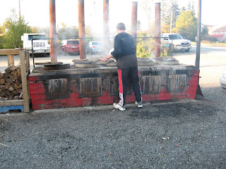
We ordered corn on the cob and cole slaw, which was extra and were told to find a spot to sit til our number was called. The tables were fairly large, so you just introduced yourself and sat down at any available chair. When your number was called, you went up and got your tray with the whole cooked lobster and the sides you had ordered. Though we felt it was pretty expensive, it was definitely the best lobster we had ever tasted, very sweet and tender. An hour later, our tummies were filled and we were ready to head back to the trailer.

The next day, we drove to Freeport, Maine to visit the LL Bean flagship store and were we ever glad we did. We both found numerous items we didn’t even know we needed! There are actually several LL Bean stores there. The flagship store, the outlet store, a biking and camping store, and boating and hunting store, and these are just LL Bean’s. Freeport’s Main Street is an outlet shoppers paradise with stores such as GAP, Coach, Timberland, Leatherman, Yankee Candles, etc. We spent all day there and made several trips back to the truck. It was definitely worth the trip if for nothing else than to just say you have been there and seen it.

Before we left Wiscasset, Maine, we had to try Red’s Eats! It is just a small dive which is well known for serving the best lobster rolls around. Once again, it was a pricey sandwich ($18.00) but you got a whole pound of lobster on the roll. George ordered crabcakes as he is not as crazy about lobster as I am and he said they were delicious as well. McKenzie got a tidbit of lobster and decided that it was a pretty good treat!

After several days in Maine, we headed over to New Hampshire and stayed in a lovely little campground amidst all the trees with their lovely red, orange and yellow leaves. We visited Portsmouth and Concord. Portsmouth was founded in 1623 and was home to sea captains, beer barons and revolutionaries. Many of the old homes of the sea captains and merchants have been restored and are in beautiful condition. One of the ones we especially liked was the Moffatt-Ladd House. It is one of America’s finest urban Georgian merchant estates. The site includes the mansion, two outbuildings, and a terraced Colonial Revival garden. Commissioned by the merchant, John Moffatt in 1760-63, the house remained in the hands of his descendants until it became a museum in 1912. Signer of the Declaration of Independence, William Whipple and his wife Katharine Moffatt Whipple lived here throughout the Revolution. Moffatt’s great granddaughter, Maria Ladd and her husband Alexander Ladd took ownership of the house in 1819. We thoroughly enjoyed strolling through the town and visiting the small shops and could easily see why it was chosen as one of the Top 50 Best Walking Cities in America.

As we were in the prime week of Fall Foliage, we drove several of the roads just looking at the beautiful autumn colors. George was justifiably impressed with the colors, having spent most of his life in Texas. The sugar maples, sycamores, and aspens were definitely showing off their rich hues with pride.

Moving on to Vermont, we noticed that the trees were dropping their leaves very quickly. Upon arriving at the campground, we learned that they had had two nights of frost, which explained the knee-deep piles of leaves. Vermont’s hills and valleys are laced with an abundance of scenic roads and highways. It is also the home to more than 100 covered bridges, of which more than 50 have been extensively repaired or restored and many listed on the National Register of Historic Places. Staying outside Brattleboro we drove scenic Route 5, up to Hanover, stopping at the King Arthur Flour Mill in Norwich which claims to be the biggest, best baking store in Vermont. We also drove over the the Colony Mill Marketplace in Keene, NH. In 1838 the prominent Faulkner and Colony families constructed a large brick building to house their woolen mill. The mill produced the finest materials for the Union troops of the Civil War and for the Allied forces of World Wars I and II. In 1953 when it closed its doors, the mill was the second oldest textile mill in the U.S. to operate under the same management in the same location. In 1983, the mill building was restored and transformed into a regional marketplace with wonderful, unusual shops inside.

Winter seems to have set in. It is barely 40 degrees today, cold, windy and drizzling, but it is just temporary. Tomorrow will be a beautiful fall day once again with temperatures in the 50’s. We stayed at home today and just relaxed and were thankful that we didn’t have to get out in the weather. Tomorrow we will head for Connecticut for a week. We are thoroughly enjoying taking our time and moving much slower than we have for the past four months. Life is definitely good!

Monday, October 6, 2008

Back to New Brunswick One More Time!


The next morning found us heading down the Fundy Coastal Drive in New Brunswick. There was a small area of the Province that we had missed when we came thru originally and we wanted to catch it on the way out.

It was a windy, drizzly day but we decided to drive up to Moncton, New Brunswick to experience Magnetic Hill. We were able to drive our truck and fifth-wheel to the foot of the hill, shift the truck into neutral, and sat tight while we coasted uphill on Mountain Road. It was quite an experience but we must admit that the magnetic hill that we enjoyed with Betty and Al, was just as good, if not better. Is it really magnetic, or magic?
McKenzie, George and I got out to look around a bit though most of the shops were already closed for the season. McKenzie enjoyed sitting in one of the chairs in the outside restaurant and seemed disappointed when no one brought her any treats.

From there, we drove over to the Hopewell Rocks for a chance to walk on the ocean floor! When we arrived, it was almost high tide and the water was coming in so we just walked around and looked a bit. Although the flower pot rocks come in a variety of different shapes and sizes, they have all been formed over millions of years by the dynamic movements of the earth and erosion from glaciers, tides, snow, ice and winds. The story of the rocks began approximately 300 million years ago when fast-flowing streams deposited thick layers of sand and gravel at Hopewell Cape from nearby Caledonia Mountains. Over time the sand and gravel compacted into layers of conglomerate rock and sandstone. Forces within the earth thrust and tilted the rock layers, creating large vertical and horizontal fractures. From this point on the flower pots began to evolve into their unique shapes. We took a few pictures of the flower pots while the tide was in. The ranger told us that once the tide is completely in, there would be just enough room to kayak under the Lover’s Arch.

Imagine 100 billion tons of water moving in and out of a bay twice every 25 hours. Powered by the gravitational pull of the moon and sun, Fundy’s tides are among the highest in the world and vary daily with the changing positions of these celestial bodies. Because the Bay of Fundy is funnel shaped – wide and deep at one end and shallow at the other, tides are pushed increasingly higher as they move up the Bay. By the time they reach “the Rocks”, the tides are over four stories high.

Big Cove and Castle Rock boast two of Hopewell’s largest and most interesting sea caves. The vertical cliffs in this area are nearly 100 feet high.

When we came back the next day at low tide, we were able to walk down on the ocean floor and look closely at the flower pots and caves. 
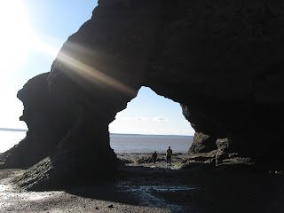
We had a window of approximately three hours to do our looking before the water returned. It was very amazing to sit on the rocks and watch the tide start coming back in. Also, a lot of fun to walk around and look at all the different carved formations.

The Bay of Fundy is a refueling stop for thousands of sandpipers on their trip south. In late summer, thousands fly from their nesting sites in the Artic. Each shorebird stops to rest and gorge constantly for about two weeks during early to mid August. From “the Rocks” the Sandpipers will fly three days and four nights non-stop to their winter home on the northern coast of South America. During their stopover, they will eat enough mud shrimp which live in the nutrient rich mud flats, to double their weight. The extra fat gives them the energy to complete their journey.

The next morning found us at Saint John, New Brunswick. We had wanted to go the City Market which houses Canada’s oldest continuing farmers’ market. The roof of the building was built like a ship's inverted hull and inside has colorful stalls displaying local produce, meat, seafood, and just about anything you want to eat. It was fun to walk thru all the displays. Once we were finished there, we walked down to the old cemetery which was established shortly after the landing of the United Empire Loyalists in 1783.

Our final stop in New Brunswick was at the Reversing Falls. Once again, we saw it at low tide and again at high tide. As the tide in Saint John Harbor rises, the downward flow in the St. John River slows and stops. The push of the Bay’s tides continues to high tide, causing the river to create rapids upstream. This happens twice in 24 hours. We have to say that this was a big disappointment. I thought we were actually going to see waterfalls reverse themselves, but it was just small rapids in the water. So, if you are short on time and need to skip something, this would probably be a good one.

We left and drove through the small villages of St. George and St. Martins and on to St. Stephen where we crossed the border into Maine. The border crossing was pretty uneventful this time. They had us pull our rig into a huge garage and x-rayed it and we were on our way. It is good to be back in the old US of A. Now we have to get reoriented to all the things we have been missing these past four months such as television, internet, US currency, etc. We thoroughly enjoyed our Canada tour this summer and can’t say enough good things about Newfoundland, but it is always nice to get back to family and friends. We’re arriving in Maine just at the fall foliage time so hopefully, we’ll be able to get some good pictures to share with you as we travel around the New England area. Love and hugs to all of you!!

Leaving Newfoundland - Back to Nova Scotia!


Though a tropical storm was hitting New Brunswick and parts of Nova Scotia, our ferry was scheduled to leave Port aux Basques on time. We noticed that there were not nearly as many of us in line waiting to go back to Nova Scotia as there had been when we were coming to Newfoundland. The ship was on time and we loaded and made our way up to the deck where we would be for the next six hours. By the time we were ready to leave port, the captain announced that we would be sitting for a while til the wind died down. About two hours later, we finally left Port aux Basques and had a pretty uneventful trip across the water, though it was quite rocky at times. We spent the night at the Arms of Gold campground in North Sydney and left early the next morning to drive to Baddeck to see the Alexander Graham Bell Museum. Along the way, we noticed that the colors of the leaves are just starting to change.

The Alexander Graham Bell Museum explores the life of a very remarkable person whose achievements have touched all of us. Artifacts, audio-visual programs and photographs tell the story of Alexander Graham Bell, a story filled with family, friends, associates and a magnificent family home still privately owned by his descendants. As a teacher, inventor and most of all a humanitarian, Bell bridged the world between sound and silence, teaching deaf people to speak and pursue ideas from transmitting sound on light to treadle-powered graphophones.
Alexander Graham Bell was born in Edinburgh, Scotland in 1847. He grew up in a family where speech and hearing were very important. His mother was an accomplished pianist, despite severe and growing deafness. Bell had just started his teaching career when tragedy struck. In 1867, his younger brother died from tuberculosis. In 1870, his older brother also died from the same disease and soon Alex was in poor health. His father decided to move the family to Ontario for a better climate.

By 1870, the race was on to improve the telegraph. Ambitious and needing money, Bell took up the challenge. Bell knew something about electricity and a lot about sound, speech and hearing. A daring idea formed in his mind: an electrical device, working much like the human ear that would transmit speech itself – a talking wire. By 1875, Bell had found a gifted assistant, Thomas Watson. On a hot day in June 1875, Watson accidentally plucked a transmitter reed on Bell’s apparatus. Bell in another room heard a sound. Watson had unexpectedly generated an electric current strong enough to activate Bell’s receiver. Could voice pulsations do the same? Bell quickly modified his apparatus and Watson could hear the muffled sound of Bell’s voice. The telephone was born! Bell received the telephone patent in February, 1876, but his apparatus had yet to transmit a clear intelligible sentence. Then on March 10, 1876, Bell’s call “Mr. Watson come here, I need you!” was clearly heard by Watson in another room. Bell’s invention was now a working reality.

While struggling with his experiments, Bell fell in love with his pupil, Mabel Hubbard. He had greatly improved her ability to speak. She helped Bell thru the many frustrations and disappointments that preceded his telephone triumph. On her 18th birthday Mabel, with her parents consent, agreed to marry Bell. They were married on July 11, 1877.

Rather than rest on his laurels, Bell was determined to show that his invention of the phone was not a fluke. In 1880, the government of France awarded Bell the prestigious Volta Prize. Now living in Washington, Bell used the prize money to establish the Volta Lab. Its purpose was to develop and market new inventions. While Bell’s mind explored the world, his heart was with the deaf. He worked hard to increase the number of qualified teachers of speech education and advocated day schools for the deaf, rather than segregated boarding schools. In 1890, Bell inspired and financed the American Association to Promote the Teaching of Speech to the Deaf. This organization merged with the Volta Bureau in 1908 and continues today as the Alexander Graham Bell Association for the Deaf.

Following a visit in 1805, Alex and Mabel Bell decided to make Baddeck, Nova Scotia their second home and named it Beinn Bhreagh. The lakes and hills of Cape Breton reminded Bell of his native Scotland. He could pursue his scientific and humanitarian interests free of the formality, distraction and summer heat of Washington.

When Bell was 59, he met F.W. “Casey” Baldwin. Baldwin was only 24, a young engineering graduate from Toronto. Mrs. Bell arranged the meeting. She knew how much her husband needed partners with practical skills and fresh ideas. With no son of their own, the Bells virtually adopted Baldwin who made Beinn Bhreagh his home for the rest of his life. Casey was fascinated by airplanes and boats of all kinds. With Baldwin at his side, Bell was destined to explore yet another exciting world – hydrofoil speedboats.

As early as 1906, Bell and Baldwin were considering another way to get a seaplane into the air – hydrofoils. Hydrofoils could lift a hull right out of the water, thus decreasing water resistance and increasing speed. Bell and Baldwin started testing hydrofoil ideas in 1908. When the U.S. entered the war in April 1917, Bell thought his best contribution would be a high speed watercraft. The U.S. Navy needed a submarine chaser. Baldwin quickly designed an 18 meter craft called the HD-4. Launched in October 1918, the HD-4 had a short but impressive career. On September 9, 1919, she made her record run of 114 kilometers per hour, a new world water speed record! By the time the HD-4 set her speed record, the war was over. Interest soon waned and there were no commercial prospects for the HD-4. Bell had been intimately involved in the development of the HD-4. It was his last great achievement. By 1920, Bell was 73 years old and tired. He died in 1922. Baldwin carried on his hydrofoil development for over 20 years.

After leaving the museum, we drove down some very beautiful roads with the fall foliage just turning, toward the town of Pictou, the birthplace of New Scotland. Their museum on the wharf was very ingenious as it had tidbits of information on tiny sailboats. However, once we stepped on board the replica of the Ship Hector, we stepped into living history.

In the early 18th century, conditions varied from area to area across the Highlands. It was not uncommon to find people living in turf hovels, scratching out a meager existence. As opportunities for a reasonable life continued to diminish, the concept of emigration began to prove to be the one reasonable avenue for escape. The Highlanders who left Lock Broom in July of 1773, were not forced to leave Scotland. For the most part, the people of the Hector made a conscious decision to leave their native soil for Nova Scotia and in doing so, purchased their passage. It was not uncommon during this period for shipping agents to solicit passengers for emigration to North America. It is estimated that between 1763 and 1775, more than 20,000 people left from the Highlands for the colonies. In one year alone, it is known that 54 emigrant ships sailed from the western sea locks with local emigrants bound for new homes in new lands. John Pagen ran an ad in Glasgow and Edinburgh promising the first 20 families 150 acres of land for man and wife and 50 more acres for every member of the family at the low rate of six pence sterling for each acre. Pagen would allow the settlers a period of 2 years to pay for their land. Transportation would not be free, with settlers required to pay in cash in advance. The cost was reasonable enough with an adult ticket costing less than the price of a cow. Little did the settlers know that while Pagen stated the land included 20 miles of coastline with good fishing and excellent soil for raising crops and livestock, he had failed to mention that it was actually located far back from the shore and was covered with thick forest.

Bound together by a desire to start new lives, committed to the journey before them, the passengers of the Hector faced an uncertain future, but did so with the conviction that whatever the future held for them in the new land, it was a certain improvement over the lives that they were leaving behind. Little did this brave band know of the hardships that lay ahead.

The Hector was registered at 200 tons berthen, which was the weight of the cargo she could carry. Her hold measurements were approximately 85 feet long with a breadth of 33 feet and a depth of 11 feet 5 inches. It was in this hold that the people of Hector, close to 200 men, women, and children would live their daily lives for nearly twelve weeks during the voyage to Pictou, Nova Scotia. The passengers were herded down the walkway to the dark, stuffy cavern which was to be their home for many weeks. In the light of the open hatch and a few fish-oil lamps slung on the bulkheads, they were shown their beds- rough pine boards with two feet of space between the upper and lower tiers.

For the first leg of their journey, the weather was fine and the passengers were able to enjoy the fresh, clean air and sunshine on deck, away from the confines of the ill-smelling hold. Water was rationed to one Scotch pint of water per day to every full freight passenger. Food was also rationed to three pounds of salt beef, four pounds of bread and four pounds of oatmeal per week. The food seemed to be sufficient to cover their needs for the voyage, although little did they know that Pagen had not loaded any provisions for their first year in Pictou, nor had he loaded even sufficient food to last the voyage. No one could foresee the terrible storm that would blow the Hector so far off her course, nor the disease that would run rampant thru the emigrants crowded into the hold. While the rations were considered plentiful enough at first, the passengers complained about the moulding oatcakes and would throw them, half-eaten into the scuppers of the ship. Hugh MacLeod would gather up these discarded scraps and keep them in a bag, possibly sensing that in the days to come, they would be sorely needed as food.

The pilgrims kept up their spirits as best they could by song, pipe music, dancing, wrestling and other amusements, through the long and painful voyage. The ship was so rotten, that the passengers could pick the wood out of her sides with their fingers. They met with a severe gale off the coast of Newfoundland and were driven back so far that it took them 14 days to get back to the point at which the storm met them. The accommodations were wretched, small pox and dysentry broke out among the passengers. Eighteen of the children died and were committed to the deep. Their stock of provisions became almost exhausted, the water became scarce and bad, adding greatly to their suffering. On September 15, 1773, the battered ship made her way into Pictou Harbor. Aided by a few settlers who had come before them, they were able to erect shelters and camps of the crudest kind for themselves and their families. Their feelings of disappointment were most bitter when they compared the actual facts that stretched before them with the comfort and prosperity that had been promised. The few who had a little money bought whatever provisions they could from the agents; while others less fortunate exchanged their clothing and other personal belongings for food. The first winter was very cruel and passed with severity unequalled to those experienced in Scotland. A number of the settlers left, unable to cope with the extreme hardships. Those that stayed survived only by working the best they could and earning small amounts of money required to barely exist. Others worked as indentured servants in other settlements. Truro was the nearest town and was many days walk through the frozen, trackless wilderness. Those that did venture there to buy potatoes and flour had to then drag the heavy sacks back thru the snow and ice to their shacks were their ill-clad, famished families huddled.

Inevitably Spring arrived and the warmth of the sun brought forth new life in the forests and new crops sprang from the small clearings that had begun to dot the landscape. Renewed with hope after surviving the harsh winter, the settlers built new homes on the land that they had cleared. For those that remained, this was now indeed their new home. For the people of Hector, this was their land, paid for by their labor, their sweat, and their hardships. It was home, the New Scotland – Nova Scotia!

Monday, September 29, 2008

Southwest Coast Adventure in Newfoundland

As we headed back down the Viking Trail, we stopped to look at the Nurse Bennett Heritage House in Daniel’s Harbor. Built in 1922, this traditional two-story house was home to Nurse Myra Bennett for 68 years. Nurse Bennett arrived on the Great Northern Peninsula in the early 1920’s. The young English nurse had signed a two-year contract that essentially named her the nurse, doctor, midwife and confidant to hundreds of people eking out a living on more than 180 miles of isolated coastline. For more than 50 years she traveled by boat and by dog team, on horse and on foot. No patient was too far away, no call came too late at night. The Heritage House, her former home has many of the tools used by Nurse Bennett to deliver 5,000 babies and extract 3,000 teeth during her career.

A few miles further down Route 430, we arrived at The Arches, which is a natural rock archway created over millions of years by a combination of glacial action, erosion by wind and water, and other geological changes. Severe storms continue to change the Arches. Far in the future they will probably be reduced to rock pillars or sea stacks.

Sally’s Cove is believed to be named after Sally Short who, along with her children, left her husband only to be shipwrecked in the cove. Today Sally’s Cove is most noted for its lobster fishery and brightly colored fishing sheds that hug the pebble beach shoreline.

We decided to try one more time to see if we could arrange to take the Western Brook boat tour in Gros Morne National Park. Last time we were booked, the winds reached 60 miles per hour and the tour was cancelled. This tour is heralded as Newfoundland’s most breathtaking water tour. The tour goes thru the dramatic Western Brook Pond fjord and is definitely a memorable experience. Carved by glaciers over a billion years ago, this 10 mile body of water happens to be Gros Morne National Park’s largest lake. Waterfalls cascade from 2,000 feet cliffs above and turn to mist before reaching the water below. A three kilometer walk to the boat docks allowed us to view the bog area as well as many of the plants and trees that were beginning to show off their fall colors. We spent one more night overlooking the Gulf of St. Lawrence and were treated to a gorgeous sunset.

As we headed further south the next morning, we got a close view of a couple of moose. The one closest to the RV had a beautiful rack but quickly ran back into the forest before I could get my camera focused. The second one, which ran across in front of us, had to be a female, because she just stood around in the brush and let me take several pictures of her. What a photo hound! Anyway, now we have seen a total of five moose on this trip. I’m not sure if I have mentioned this before but moose are not native to the province. In 1904, four were taken off a train at Howley and introduced into the wild where their numbers grew quickly.

Still further south, around Steady Brook, is the location of Marble Mountain Ski Resort. Though I don’t ski anymore (too old and too clumsy), I can just imagine “shooshing” down the mountainside.

On route 1 (Trans Canada Highway), the Old Man in the Mountain watches every vehicle that makes the 35 mile drive from Corner Brook to Deer Lake. Legend has it that Spanish pirates buried treasure on Shellbird Island, and that a weatherbeaten old man is guarding the riches. Can you spot his face in the rock formation?

We stopped briefly in Corner Brook but quickly decided that it was not a town we wanted to spend much time in. Too crowded and built on a hillside with tiny, narrow roads. Further down the road we spotted fishing villages, lobster dorys painted bright orange and a fishing boat peacefully bobbing out in the bay. The fog and low lying clouds made a perfect picture and as we drove along, we noticed the red leaves of the maple trees which were becoming very vibrant.

Stephenville is a town which has the distinction of being both a sea port and an airport. An F-102 Delta Dagger aircraft, permanently grounded next to town hall, was presented as a memorial to the former Ernest Harmon Air Force Base, located there from 1941-1966. While there, we took a detour and drove routes 460 and 463 which are named the French Ancestors Route. We could definitely tell we were back in the country of the French heritage as we noticed the unusual yard ornamentations. We visited our Lady of Mercy church, the largest wooden structure in Newfoundland, checked out Red Island, named for its red cliffs, and visited the province’s only alpaca and llama farm. We drove across a wooden bridge and arrived at another wooden church, Holy Trinity Anglican church which was built in 1914 and while it is not the largest, it well may be the oldest, in the community.

On Routes 406 and 407, we entered Codroy Valley. People here live off the land. They raise dairy cows, sheep, and horses. The fertile valley is known for its agricultural products. Framed by the Long Range and Anguille mountains, and the Atlantic Ocean, Codroy Valley is comprised of 15 communities and a population of 2,200. A walk thru the Valley’s Wetlands allows you to view up to 200 species of migratory birds. Further along the coast, we stopped to view the Cape Anguille Light Station. Since the early 1900s this beacon of refuge and safety has been tended by a member of the Patry family. This site is also the most western site in Newfoundland. We have now been on the farthest points of each side of the island.

Today is our last full day on the island. We will be heading out on the Port aux Basques ferry tomorrow which is the shorter of the two ferries. Port aux Basques is the “gateway to Newfoundland”. This ice-free port was a 16th century fishing station for French, Portuguese and Basques fishermen seeking shelter when violent storms whipped the Gulf of St. Lawrence into a white-crested fury. It is also a former railway town; the final port of call for the infamously slow Newfie Bullet – rumoured to take more than 27 hours to reach this town from St. John’s.

We traveled past Port aux Basques on route 470 to Isle aux Morts called Deadman’s Island by the French. The name reflects the many ships wrecked on these shores. A hike sounded like a good idea so we hiked Harvey’s Trail. George Harvey was a local hero famous for saving nearly 200 people in two shipwrecks off the coast of Isle aux Morts. He fished in the summer and rested in the winter. With the fish he caught, he bought commodities like flour, sugar and molasses to tide him and his family over in winter. The weather was rough and there were no other families on the island for company. He often buried bodies that would float ashore from shipwrecks he did not even know occurred. Shipwrecks and the Newfoundland coast are two items that belong together, especially at Isle aux Morts. An estimated 3,000 shipwrecks have occurred along the southwest coast over the last 130 years.

The two biggest feats in his life came in 1828 and 10 years later in 1838. July 10, 1828 could hardly be called a summer’s day as hurricane force winds whipped thru the area. George Harvey was a Newfoundland fisherman and could tell this was going to be a fierce storm. That night George got up, put on his rubber gear and took a walk along the beach. There he discovered driftwood and some supplies. He knew from experience there was a wreck nearby. The Despatch, after a navigation error had landed on Wreck Bay. The vessel’s mission was to take a load of Irish immigrants to Quebec City where they were going to make a new life for themselves. George rushed back to his small two room bungalow and told his family what he had seen. Immediately his 17 year old daughter, Anne, and his 12 year old son, Tom, volunteered to go with their father. It was two days before the water was stable enough for them to launch their punt. When it was possible, off they went with their Newfoundland dog, Hairyman, in tow.

The passengers who were aboard the Despatch had no way of getting off the ship. Every time they’d launch a long boat, it would get swept back in, destroying the boat and leaving nothing but driftwood behind. All they could do was wait, cling to the rocks, and hope to be rescued. George, Anne, and Tom launched their 12 foot punt into the raging waters. They put aside any concern for their own welfare. With Anne moving the main oars and Tom the rear, the Harvey family rowed about three miles. The fierceness of the ocean made going right up to the ship impossible. George decided to keep the boat positioned where it was. With no other way of reaching the stranded voyagers, George tied a rope around his Newfoundland dog, Hairyman, and ordered him into the water and to the vessel. The dog knew just what to do. He fought the big waves and after being driven back several times, he finally reached the brig and was eagerly drawn aboard. Once there, the crew tied another rope around the dog and without any instructions, he returned to his master. With the dog aboard the punt, the Harveys had the task of getting back to the nearest point of land, a little over a mile away. This meant an extreme amount of work on the oars through vicious seas. George Harvey knew only too well the mood of the ocean. It was a good possibility that the punt would capsize and the family could drown. It was a chance he decided to take as about 200 lives depended on him. Luck was on their side that night for the huge sea took them and placed them near the shore. When the sea receded, the punt was land bound. Quickly they tied their boat and began to drag the stout cable that the Despatch had sent to them and strung the cable tightly between ship and land. Though the conditions were hazardous, the crew on the slowly sinking ship set up buoys and soon transported the passengers to land. Just as the last man came off the buoy, the Despatch slid off the rocks and under the sea. George clothed and fed the people with his meager supplies and rowed a long boat eight miles to Port aux Basques to report the wreck. About four days later a ship was sent to retrieve the survivors and took them to their original destination of Quebec City. George received a special medal from King George IV to commemorate the brave rescue. He was also given 100 pounds of Sterling Silver from Lloyds of London.

On September 14, 1838, a similar incident happened. The captain of the Rankin was trying to change course and soon found his 650 ton cargo ship grounded. He began firing rockets, hoping someone would see them. As luck would have it, Anne and George were walking along the shore and saw the distress signals. They once again launched their 12 foot punt into the sea. Fortunately, the seas had abated some and they were able to row their little boat up to the ship. Then in groups of three, the Harveys took the clinging survivors to shore one mile away. Once again the Harveys opened their home and provisions to these 25 until a rescue vessel could be dispatched to take the survivors safely home. We enjoyed the hike and the history lesson and McKenzie did a really great job of walking the trail and climbing the stairs along the way.

Our next stop was Burnt Islands where a causeway was built to link a single community divided by water. We couldn’t resist taking a picture of the local grocery story and filling station that provides services for this small fishing village.

The last stop for the day was a trip out to the Rose Blanche lighthouse. This is one of the last granite lighthouses on the Atlantic seaboard. It was built in 1871 from a nearby granite quarry. The building operated as a lighthouse from 1873 to the 1940s. There were six keepers over the approximately 70 years of the lighthouse’s existence. After it was abandoned, the building fell into ruins. In 1988 the Southwest Development Association and other community groups began the long process of restoring the structure to its former condition. Actual restoration began in 1996 and was completed in two years. The reconstructed lighthouse is furnished with 19th century reproduced furniture and local antiques. One remarkable feature is the stone steps within the tower walls which kept the tower from collapsing after it was abandoned.

McKenzie enjoyed tossing a coin into the old well and making a wish. (I wonder how many dog treats she wished for?)
We were all pretty well tired by the time we got back to the trailer. These past 6 ½ weeks have been wonderful. Though we are looking forward to getting back to the States (TV and internet – Yeah!!), we are sad to have this trip coming to an end. Here, there is no road rage and very little graffiti. Though the island is a paradise, the people are what make it so great. The moment you lose faith in people, it’s time to come to Newfoundland. Here you will hear them laugh at themselves, sing songs and tell tales. If you need a hand, you get an army. They treat you for who you are and don’t put on phony airs. It is truly a place that will continue to live on inside of us long after we’ve traveled on to new adventures. We hope you’ve enjoyed the trip as much as we have and maybe some day you’ll want to experience the lime green, bright yellow and aquamarine houses spilling into the harbor, for yourself.

St. Anthony - Newfoundland


The Viking Trail continues on to St. Anthony, where another visitor had quite a different impact. Dr. Wilfred Grenfell brought modern medicine to northern Newfoundland and the remote communities of coastal Labrador beginning in the 1890s.

The Grenfell house was built in 1909-1910. Originally standing alone on the hill, the house became knows as “the castle” with flower beds and vegetable gardens. Now, taken over by wildflowers and shaded by trees, it offers a quiet welcome to visitors from around the world. The home has been restored with most of the original furnishings and tells the life story of Wilfred Thomason Grenfell and his wife Anne MacClanahan Grenfell. The airy veranda was exceptionally peaceful and overlooking the harbor, you can understand why the doctor and his wife chose this piece of property for the location of their home.

The name Dr. Wilfred Grenfell is synonymous with the history and development of the tip of the Great Northern Peninsula and the Labrador coast. The reason he is held in high regard is that he was more than a doctor. Dr. Grenfell was a spiritual leader, a driving force behind economic development and a believer in helping people do things for themselves.

A trail behind the house, ambles up into the hills. It was across these “White Hills” that Dr. Grenfell set out in 1908 on his dog team to attend a patient in Englee, some 50 miles to the south of St. Anthony. He loved this area and requested that when he died, his ashes be buried here. Inset in a large boulder are the ashes of Sir Wilfred and Lady Grenfell, along with four other prominent figures who played significant roles in the ongoing development of Grenfell Mission.

The Grenfell Interpretation Center depicts his life. He was born February 25, 1865 in a small coastal town in the north of England. In 1883 he entered London Hospital Medical School. While in London, he heard the American evangelist, Dwight L. Moody, speak and his words changed Grenfell’s life and he decided to commit his life to Christ. Grenfell joined the Royal National Mission to Deep Sea Fishermen, an organization which provided medical and spiritual services to North Sea fishermen. In 1897, he was sent to Newfoundland to investigate the conditions in the Labrador fishery. “We’re wonderful glad to have you” a fisherman said, “We’ve never had a doctor in these parts before”. This was the start of Grenfell’s lifelong work on a coast that was ice blocked and inaccessible for many months of the year. He was devoted to improving the lives of the people. He practiced medicine, built hospitals, established schools and orphanages and when not working on the coast, traveled in the United Kingdom and North America looking for support and labor.

By 1908, Grenfell and his work were well known in Canada, England and the USA, but the events of Easter Sunday, 1908, assured his reputation worldwide. In response to an emergency call, he set off by dogsled across the frozen land to Hare Bay. It was spring and the ice was breaking up. Heedless of the danger, he crossed the Bay. The ice gave way and he was cast into the frigid water. Struggling with his dogs, he finally reached a 12 foot icepan and climbed on freezing, cold and soaking wet. The stage was set for the worst ordeal of his life. Grenfell was in fine physical condition and mentally shrewd enough to rationalize his predicament. He knew that the icepan would soon begin melting and that his six dogs and he would suffer hypothermia as the cold, winds of night blew in. He had to make a decision and though he said it felt like murder, he killed three of his largest dogs and used their hides to wrap up in, while snuggling together with the remaining three. He had made previous arrangements, that if he did not show up by a specified time, a search party should be sent out. His optimism, ingenuity, calmness and religious faith held him at arms length from death’s door through the night as the ice carried him toward the open sea. At first light, five men pushed and rowed a boat thru slush, ice and open water to save “their beloved doctor”. The details of this survival circulated in newspapers worldwide and Grenfell wrote his account in a booklet, sold for fundraising. In his home, he has a wood and brass plaque that honors the three dogs who gave their lives to save his.

Grenfell authored 33 books, published hundreds or articles, created Christmas cards to provide for the Children’s Homes and held prayer meetings on mission ships, wharfs, and fishing boats. In 1892, there were no magistrates on the entire Labrador coast. The Newfoundland government appointed Grenfell as an unpaid magistrate and justice of the peace. He established a network of hospitals and nursing stations that stretched the length of the northern Newfoundland and Labrador coast, and created Children’s Homes for children who were orphans or who could not be cared for by their parents. During his life, he received many honors and awards for his dedicated work and in 1928, he was made a Knight Commander of the Order of St. Michael and St. George.

Grenfell met Anne MacClanahan, the daughter of a U.S. Confederate Army Officer while on board a ship returning from a fund raising tour in England. They were married in 1909 and came to live in the Grenfell house which they had designed together. Anne gave Grenfell’s life comfort and refinement and she became totally involved in his work. She organized his fundraising, tours and lectures, edited his books, and helped secure scholarships for the children of the area to continue their education. She died of cancer in 1938.

As time passed, organizations such as the New England Grenfell Association and the Grenfell Association of America shouldered more and more responsibility for the Labrador work and the Royal National Mission to Deep Sea Fishermen was reduced. In 1912, the Grenfell Association (IGA) came into being. By the late 1920’s the pace had begun to take its toll and Grenfell had his first series of heart attacks. Grenfell died in Vermont on October 9, 1940. When Grenfell died, the mission survived and continued under the guiding hand of Dr. Charles Curtis. In 1937, the mission’s assets included 6 hospitals, 7 nursing stations, 2 hospital ships and assorted vessels, 12 clothing distributions, King George the Fifth Institute in St. John’s, the supply schooner George B. Cluett, and a haul up slip for schooner repairs.

Becoming a province of Canada in 1949, brought more change. Canadian family allowances, old age pensions, and many other benefits meant improved living standards. Federal and Provincial governments began funding health care. As the need for charity diminished, IGA fund raising branches gradually fell dormant. In 1981, the Association passed to the Province, all health related assets for the sum of $1.00. The Province in turn, set up the Grenfell Regional Health Services, under the direction of a local board.

The northern portion of the Great Northern Peninsula has Newfoundland’s longest iceberg-watching season off Fishing Point. Iceberg Alley runs right by the Fishing Point Lighthouse. This is also an excellent place to spot whales. After standing out in the cold wind looking for whales (obviously we weren’t going to see any icebergs this time of year), we decided we’d stop in the Lightkeeper’s Seafood Restaurant and have lunch. This way we could still watch for whales in the warmth of the restaurant. George had fishcakes and I had a fishburger that was so big that George ended up having to eat half of it. Still no whales. I guess the few we saw playing off May Point is all we are going to see this trip.

We have thoroughly enjoyed being here at this time of year after most of the other tourists have headed for warmer climates but if you are interested in eating lobster, seeing whales frolicking in the ocean, watching crystal blue icebergs sail down the ocean, and being part of all the “tourist” attractions, then it would be better to arrive here no later than June. We are finding some of the touristy stuff is closed, which really doesn’t matter to us as we were more interested in learning the history of the land and its people and we have probably driven 2400 miles around the island, poking our noses in most of the nooks and crannies. In a day or so, we will be heading down to the southern portion of the western peninsula – the final portion of our trip. We arrived here as strangers, but we are leaving as family and it will be sad to go. The concept of “paradise found” is not about stumbling upon some ready-made bliss. Rather, it entails nothing less than a willingness to see things differently, to surrender yourself to the inevitable surroundings, to lose a bit of the old you to discover a new you. And, that is what we’ve found in Newfoundland!

Gros Morne & L'Anse aux Meadows - Newfoundland

Hang on to your hats, we’re on the Viking Trail! This trail has its base at Deer Lake and follows a northward journey for approximately 315 miles to the tip of the peninsula at St. Anthony. This vibrant region offers a wide range of natural and cultural experiences, including Gros Morne National Park and L’Anse aux Meadows, home to the Vikings.

Heading to our first stop, Gros Morne, we passed lots of tall evergreen trees, blue waters and white, sandy beaches. From the scars and rocky rubble left on the earth’s surface by tectonic forces, to the natural beauty of seascapes, mountaintops, and tracts of forests – the park is beauty magnified. There is the beautiful Western Brook Pond, a gigantic glacier-carved fjord with sides 2,000 feet high, over 60 miles of hiking trails, beaches of many types, and a quaint lighthouse. There’s even a theatre festival which we decided to attend the first night we arrived. The Gros Morene Theatre Festival has been entertaining audiences for the past twelve years. It is a professional theatre with over 40 professional actors, musicians, writers, designers and technicians. The play we attended was “A Rum for the Money” which was a comedy drama set in the 1960’s in a small dory on the waters between Newfoundland and St. Pierre & Miquelon. Three Newfoundland men were on a rum running mission in the middle of the night escaping and dodging French bullets and then evading R.C.M.P. cutters when they are hit and broken apart by a mysterious night vessel. An eerie night ensues as our three rum runners question their lot in life as inexplicable happenings engulf them. We enjoyed the play but did not enjoy the ride back home after dark, trying to make sure we didn’t have a face-to-face meeting with a moose! We stayed in a campground that allowed us to back up directly over the ocean, allowing us views of beautiful sunsets and gentle rolling waves. We were the only ones in the campground, so it felt like our own private slice of heaven. And, true to its reputation – the weather changed! As one local put it, “You can enjoy all the seasons in one day here in Newfoundland”! We started out with a beautiful sunny day with a mild breeze and gently rolling waves. (View out our side window.) By noon, the temperature had dropped and it was cloudy. At 1:00 p.m., when we were due to take our boat tour of the inland fjord, the winds reached 50 miles per hour and the boat trip was cancelled. We’ll try to catch one on our way back down the peninsula. As we hiked back, the wind was so strong, it practically blew us off the boardwalk over the bog! By the time, we got back to the trailer, McKenzie was hanging onto the back of the sofa for dear life as it bobbed and weaved with the tremendous winds. Temperatures had dropped to the 40’s! The ocean was magnificent! The waves were crashing on the shore and the white froth was blowing everywhere! Though we could have done without the wind, it was an exciting opportunity to experience.

Before the change in the weather, we had taken a ride over to Rocky Harbor to visit the lighthouse at Lobster Cove Head which has guided ships safely into Bonne Bay for over a century. Until the late 1800’s, there was no lighthouse at the entrance. Each inhabitant of Rocky Harbor donated a pint of oil per week to keep a light in the window of a local home. In 1897, the pre-fabricated cast iron sections of the lighthouse were hauled up from shore by oxen. It first cast its beam in April, 1898. George and McKenzie enjoyed the view but couldn’t imagine oxen carting the lighthouse up these steep cliffs. Since George and I had bought Newfoundland t-shirts, we figured McKenzie deserved one too. She enjoyed modeling hers!
On a still day, with the Tablelands reflected in the waters of Bonne Bay, it is difficult to imagine the dangers that lurk beneath the calm. In places the water is very deep making safe anchorage for boats difficult. This area can be the site of punishing hurricane force winds when a cold easterly flow drops down from the highlands and compresses in the valley. As this air flows out, it creates a low pressure area which results in winds that can blow the roofs off houses and produce waves that damage local wharfs.

We decided we’d had enough of the high winds, rain, and waves and headed up the peninsula. The pounding surf was still showing its anger as we drove thru Sally’s Cove. But a little further down the road, there was a weather change and the rain and wind stopped. As we drove, we noticed garden plots lining the sides of the roads, without a house in site. We were told that these are roadside gardens, nurtured and maintained by residents of the nearby towns, who take great pride in their ability to grow fresh, tasty vegetables. Looking like mini-plots of farmland, the gardens are fenced off with an array of posts and sticks and guarded by makeshift scarecrows, tin cans and plastic bags. These small plots – located miles from a community – provide their owners with vegetables which are harvested in late summer or fall and stored in root cellars during the winter. No one ever touches anyone else’s garden or the bounty from it. It’s just a way of life!

Another oddity that we noticed as we drove along was the wood that had been cut and stacked into a “teepee” shape. This is to allow the wood to dry and the moisture to run out. Once this happens, the wood is then cut and stacked – again all along the roadside. Each family cuts and stacks their own wood and as they need it, they drive their trucks or skidoos to their stack and fill them up. Once again, the Newfoundland Code of Behavior, prevents any “borrowing” off your neighbor’s stack.

While species like cod are in decline, lobster is king along this shore and we saw hundreds of lobster traps stacked up along the side of the road. The lobster enters the hole made in the net and gets caught and can’t get back out. Too bad we weren’t here in June!

Labrador is just a ferry crossing away. Though we would love to go there, it is not on the agenda for this trip as the weather is starting to push us southward. Labrador is recognized as one of the last great wilderness areas in the world and perhaps we’ll come back one summer to spend some time there.

L’Anse aux Meadows was, and still is, a tiny fishing village. The Northern Peninsula is land’s end for Newfoundland and North America, with the northern end of the Island jutting into the Labrador Sea. George stood on the most Northern part of Newfoundland for a picture.

L’Anse aux Meadows was first brought to the attention of the world in 1960 thanks to Dr. Helge Ingstad, a historian and explorer, and his wife Anne Stine Ingstad, an archaelogist. This Norwegian couple was determined to prove the North American existence of the legendary site spoken of in the Norse Sagas. Their years of searching came to an end when they met George Decker, a local fisherman. He noticed unusual grassy mounds in the area, the type the Ingstads were searching for. Twelve years of archaeological research followed, conducted first by the Ingstads and then by Parks Canada. Those grassy mounds turned out to be remnants of eight 11th century Norse buildings. During their work in the 1960’s and 70’s, archaeologists uncovered remnants of iron production – an important early clue that Vikings had visited the site. Only the Norse, had the ability and technology to produce iron from bog ore.
It is documented that a substantial Viking expedition from Greenland landed on the shores of what is now L’Anse aux Meadows around the year 1000. Under the leadership of Leif Eiriksson, the group of between 70-90 people established an encampment that served as the base for exploring south throughout the Gulf of St. Lawrence. Over the next couple of decades, the Vikings would make a number of voyages to this region of the world they called Vinland, mainly in search of hardwood lumber since Greenland has no trees. These trips would result in the first contact between Europeans and North American Aboriginal Peoples.

The National Historic site is a model which illustrates how the site may have looked at the time of the Norse. In addition to the remains of the Norse buildings, there are three full scale replicas of sod huts. Our costumed Viking interpreters explained many of the customs and much of the history as we toured the site. For instance, did you know that the Vikings did not have horns on their helmets? This was Hollywood taking a free license to make them look more fierce. The sod huts were smoky inside and as I wandered outside to get a fresh breath of air, I roamed right into the middle of the filming crew who were trying to make a Tourism film. For some reason, they did not want me in the picture, but were very polite in apologizing for interrupting my tour, as they shooed me away from the area.

On our walk back to the Historic center, we stopped to view the sculpture, a “Meeting of Two Worlds” which is an interpretive artwork that captures the historical significance of L’Anse aux Meadows. It was developed in two parts; one completed by Newfoundland and the other by Sweden. Symbolically corresponding to the geographic points of departure and landing of the Vikings, the two pieces come together to form an archway over the walking trail leading to the archaeological site. Where the two elements meet, the artistic styles fuse, representing the first contact between the European and North American Aboriginal cultures.

Well, that was a bit beyond my comprehension, but what I did comprehend was two moose out in the field chomping away at the bog plants. Gosh they were huge! I didn’t get a very good picture as they were quite a ways away, but will share it with you anyway. This makes a total of three moose we have seen in the last two days. The first one came out of the woods as we were driving down the road. I yelled and by the time I was able to get the words out of my mouth, George saw it and tried to begin slowing down. Fortunately, we must have surprised him as much as he surprised us because he just stood there for a minute looking at us as if to say “What in the heck is that ?” and then just as our trailer passed him, he took off across the road right behind us. That was a little too up close and personal for us!

We headed back to our trailer and decided to rest for the remainder of the day. Tomorrow will be another adventure to St. Anthony!