Hang on to your hats, we’re on the Viking Trail! This trail has its base at Deer Lake and follows a northward journey for approximately 315 miles to the tip of the peninsula at St. Anthony. This vibrant region offers a wide range of natural and cultural experiences, including Gros Morne  National Park and L’Anse aux Meadows, home to the Vikings.
Heading to our first stop, Gros Morne, we passed lots of tall evergreen trees, blue waters and white, sandy beaches. From the scars and rocky rubble left on the earth’s surface by tectonic forces, to the natural beauty of seascapes, mountaintops, and tracts of forests – the park is beauty magnified. There is the beautiful Western Brook Pond, a gigantic glacier-carved fjord with sides 2,000 feet high, over 60 miles of hiking trails, beaches of many types, and a quaint lighthouse. There’s even a theatre festival which we decided to attend the first night we arrived. The Gros Morene Theatre Festival has been entertaining audiences for the past twelve years. It is a professional theatre with over 40 professional actors, musicians, writers, designers and technicians. The play we attended was “A Rum for the Money” which was a comedy drama set in the 1960’s in a small dory on the waters between Newfoundland and St. Pierre & Miquelon. Three Newfoundland men were on a rum running mission in the middle of the night escaping and dodging French bullets and then evading R.C.M.P. cutters when they are hit and broken apart by a mysterious night vessel. An eerie night ensues as our three rum runners question their lot in life as inexplicable happenings engulf them. We enjoyed the play but did not enjoy the ride back home after dark, trying to make sure we didn’t have a face-to-face meeting with a moose! We stayed in a campground that allowed us to back up directly over the ocean, allowing
 us views of beautiful sunsets and gentle rolling waves. We were the only ones in the campground, so it felt like our own private slice of heaven. And, true to its reputation – the weather changed! As one local put it, “You can enjoy all the seasons in one day here in Newfoundland”! We started out with a beautiful sunny day with a mild breeze and gently rolling waves. (View out our side window.)
 By noon, the temperature had dropped and it was cloudy. At 1:00 p.m., when we were due to take our boat tour of the inland fjord, the winds reached 50 miles per hour and the boat trip was
 cancelled. We’ll try to catch one on our way back down the peninsula. As we hiked back, the wind
 was so strong, it practically blew us off the boardwalk over the bog!
 By the time, we got back to the trailer, McKenzie was hanging onto the back of the sofa for dear life as it bobbed and weaved with the tremendous winds. Temperatures had dropped to the 40’s! The ocean was magnificent! The waves were crashing on the shore and the white froth was
 blowing everywhere! Though we could have done without the wind, it was an exciting opportunity to experience.
Before the change in the weather, we had taken a ride over to Rocky Harbor to visit the lighthouse at Lobster Cove Head which has guided ships safely into Bonne Bay for over a century. Until the late 1800’s, there was no lighthouse at the entrance. Each inhabitant of Rocky Harbor donated a pint of oil per week to keep a light in the window of a local home. In 1897, the pre-fabricated cast iron sections of the lighthouse were hauled up from shore by oxen.
 It first cast its beam in April, 1898. George and McKenzie enjoyed the view but couldn’t imagine oxen carting the lighthouse up these steep cliffs. Since George and I had bought Newfoundland t-shirts, we figured McKenzie deserved one too. She enjoyed modeling hers!

On a still day, with the Tablelands reflected in the waters of Bonne Bay, it is difficult to imagine the dangers that lurk beneath the calm. In places the water is very deep making safe anchorage for boats difficult. This area can be the site of punishing hurricane force winds when a cold easterly flow drops down from the highlands and compresses in the valley.
 As this air flows out, it creates a low pressure area which results in winds that can blow the roofs off houses and produce waves that damage local wharfs.
We decided we’d had enough of the high winds, rain, and waves and headed up the peninsula. The pounding surf was still showing its anger as we drove thru Sally’s Cove. But a little further down the road, there was a weather change and the rain and wind stopped. As we drove, we noticed garden plots lining the sides of the roads, without a house in site. We were told that these are roadside gardens, nurtured and maintained by residents of the nearby towns, who take great pride in their ability to grow fresh, tasty vegetables. Looking like mini-plots of farmland, the gardens are fenced off with an array of posts and sticks and guarded by
 makeshift scarecrows, tin cans and plastic bags. These small plots – located miles from a community – provide their owners with vegetables which are harvested in late summer or fall and stored in root cellars during the winter. No one ever touches anyone else’s garden or the bounty from it. It’s just a way of life!
Another oddity that we noticed as we drove along was the wood that had been cut and stacked into a “teepee” shape. This is to allow the wood to dry and the moisture to run out. Once this happens, the wood is then cut and stacked – again all along the roadside. Each family cuts and stacks their own wood and as they need it, they drive their trucks or skidoos to their stack and
 fill them up. Once again, the Newfoundland Code of Behavior, prevents any “borrowing” off your neighbor’s stack.
While species like cod are in decline, lobster is king along this shore and we saw hundreds of lobster traps stacked up along the side of the road. The lobster enters the hole made in the net and gets caught and can’t get back out. Too bad we weren’t here in June!

Labrador is just a ferry crossing away. Though we would love to go there, it is not on the agenda for this trip as the weather is starting to push us southward. Labrador is recognized as one of the last great wilderness areas in the world and perhaps we’ll come back one summer to spend some time there.
L’Anse aux Meadows was, and still is, a tiny fishing village. The Northern Peninsula is land’s end for Newfoundland and North America,
 with the northern end of the Island jutting into the Labrador Sea. George stood on the most Northern part of Newfoundland for a picture.
National Park and L’Anse aux Meadows, home to the Vikings.Heading to our first stop, Gros Morne, we passed lots of tall evergreen trees, blue waters and
white, sandy beaches. From the scars and rocky rubble left on the earth’s surface by tectonic forces, to the natural beauty of seascapes, mountaintops, and tracts of forests – the park is beauty magnified. There is the beautiful Western Brook Pond, a gigantic glacier-carved fjord with sides 2,000 feet high, over 60 miles of hiking trails, beaches of many types, and a quaint lighthouse. There’s even a theatre festival which we decided to attend the first night we arrived. The Gros Morene Theatre Festival has been entertaining audiences for the past twelve years. It is a professional theatre with over 40 professional actors, musicians, writers, designers and technicians. The play we attended was “A Rum for the Money” which was a comedy drama set in the 1960’s in a small dory on the waters between Newfoundland and St. Pierre & Miquelon. Three Newfoundland men were on a rum running mission in the middle of the night escaping and dodging French bullets and then evading R.C.M.P. cutters when they are hit and broken apart by a mysterious night vessel. An eerie night ensues as our three rum runners question their lot in life as inexplicable happenings engulf them. We enjoyed the play but did not enjoy the ride back home after dark, trying to make sure we didn’t have a face-to-face meeting with a moose! We stayed in a campground that allowed us to back up directly over the ocean, allowing us views of beautiful sunsets and gentle rolling waves. We were the only ones in the campground, so it felt like our own private slice of heaven. And, true to its reputation – the weather changed! As one local put it, “You can enjoy all the seasons in one day here in Newfoundland”! We started out with a beautiful sunny day with a mild breeze and gently rolling waves. (View out our side window.) By noon, the temperature had dropped and it was cloudy. At 1:00 p.m., when we were due to take our boat tour of the inland fjord, the winds reached 50 miles per hour and the boat trip was cancelled. We’ll try to catch one on our way back down the peninsula. As we hiked back, the wind was so strong, it practically blew us off the boardwalk over the bog! By the time, we got back to the trailer, McKenzie was hanging onto the back of the sofa for dear life as it bobbed and weaved with the tremendous winds. Temperatures had dropped to the 40’s! The ocean was magnificent! The waves were crashing on the shore and the white froth was blowing everywhere! Though we could have done without the wind, it was an exciting opportunity to experience.Before the change in the weather, we had taken a ride over to Rocky Harbor to visit the
lighthouse at Lobster Cove Head which has guided ships safely into Bonne Bay for over a century. Until the late 1800’s, there was no lighthouse at the entrance. Each inhabitant of Rocky Harbor donated a pint of oil per week to keep a light in the window of a local home. In 1897, the pre-fabricated cast iron sections of the lighthouse were hauled up from shore by oxen. It first cast its beam in April, 1898. George and McKenzie enjoyed the view but couldn’t imagine oxen carting the lighthouse up these steep cliffs. Since George and I had bought Newfoundland t-shirts, we figured McKenzie deserved one too. She enjoyed modeling hers! On a still day, with the Tablelands reflected in the waters of Bonne Bay,
it is difficult to imagine the dangers that lurk beneath the calm. In places the water is very deep making safe anchorage for boats difficult. This area can be the site of punishing hurricane force winds when a cold easterly flow drops down from the highlands and compresses in the valley. As this air flows out, it creates a low pressure area which results in winds that can blow the roofs off houses and produce waves that damage local wharfs.We decided we’d had enough of the high winds, rain, and waves and headed up the peninsula. The pounding surf was still showing its anger as we drove thru Sally’s Cove.
But a little further down the road, there was a weather change and the rain and wind stopped. As we drove, we noticed garden plots lining the sides of the roads, without a house in site. We were told that these are roadside gardens, nurtured and maintained by residents of the nearby towns, who take great pride in their ability to grow fresh, tasty vegetables. Looking like mini-plots of farmland, the gardens are fenced off with an array of posts and sticks and guarded by makeshift scarecrows, tin cans and plastic bags. These small plots – located miles from a community – provide their owners with vegetables which are harvested in late summer or fall and stored in root cellars during the winter. No one ever touches anyone else’s garden or the bounty from it. It’s just a way of life!Another oddity that we noticed as we drove along was the wood that had been cut and stacked into a “teepee” shape. This is to allow the wood to dry and the moisture to run out. Once this
happens, the wood is then cut and stacked – again all along the roadside. Each family cuts and stacks their own wood and as they need it, they drive their trucks or skidoos to their stack and fill them up. Once again, the Newfoundland Code of Behavior, prevents any “borrowing” off your neighbor’s stack.While species like cod are in decline, lobster is king along this shore and we saw hundreds of lobster traps stacked up along the side of the road.
The lobster enters the hole made in the net and gets caught and can’t get back out. Too bad we weren’t here in June! Labrador is just a ferry crossing away. Though we would love to go there, it is not on the agenda for this trip as the weather is starting to push us southward. Labrador is recognized as one of the
last great wilderness areas in the world and perhaps we’ll come back one summer to spend some time there.L’Anse aux Meadows was, and still is, a tiny fishing village.
The Northern Peninsula is land’s end for Newfoundland and North America, with the northern end of the Island jutting into the Labrador Sea. George stood on the most Northern part of Newfoundland for a picture. L’Anse aux Meadows was first brought to the attention of the world in 1960 thanks to Dr. Helge Ingstad, a historian and explorer, and his wife
 Anne Stine Ingstad, an archaelogist. This Norwegian couple was determined to prove the North American existence of the legendary site spoken of in the Norse Sagas. Their years of searching came to an end when they met George Decker, a local fisherman. He noticed unusual grassy mounds in the area, the type the Ingstads were searching for. Twelve years of archaeological research followed, conducted first by the Ingstads and then by Parks Canada. Those grassy mounds turned out to be remnants of eight 11th century Norse buildings.
 During their work in the 1960’s and 70’s, archaeologists uncovered remnants of iron production – an important early clue that Vikings had visited the site. Only the Norse, had the ability and technology to produce iron from bog ore.

It is documented that a substantial Viking expedition from Greenland landed on the shores of what is now L’Anse aux Meadows around the year 1000. Under the leadership of Leif Eiriksson, the group of between 70-90 people established an encampment that served as the base for
 exploring south throughout the Gulf of St. Lawrence.
 Over the next couple of decades, the Vikings would make a number of voyages to this region of the world they called Vinland, mainly in search of hardwood lumber since Greenland has no trees. These trips would result in the first contact between Europeans and North American Aboriginal Peoples.
The National Historic site is a model which illustrates how the site may have looked at the time of the Norse.
 In addition to the remains of the Norse buildings, there are three full scale replicas of sod huts.
 Our costumed Viking interpreters explained many of the customs and much of the history as we
 toured the site. For instance, did you know that the Vikings did not have horns on their helmets? This was Hollywood taking a free license to make them look more fierce. The sod huts were smoky inside and as I wandered outside to get a fresh breath of air, I roamed right into the middle of the filming crew who were trying to make a Tourism film.
 For some reason, they did not want me in the picture, but were very polite in apologizing for interrupting my tour, as they shooed me away from the area.
On our walk back to the Historic center, we stopped to view the sculpture, a “Meeting of Two Worlds” which is an interpretive artwork that captures the historical significance of L’Anse aux
 Meadows. It was developed in two parts; one completed by Newfoundland and the other by Sweden. Symbolically corresponding to the geographic points of departure and landing of the Vikings, the two pieces come together to form an archway over the walking trail leading to the archaeological site. Where the two elements meet, the artistic styles fuse, representing the first contact between the European and North American Aboriginal cultures.
Well, that was a bit beyond my comprehension, but what I did comprehend was two moose out in the field chomping away at the bog plants.
 Gosh they were huge! I didn’t get a very good picture as they were quite a ways away, but will share it with you anyway.
 This makes a total of three moose we have seen in the last two days. The first one came out of the woods as we were driving down the road. I yelled and by the time I was able to get the words out of my mouth, George saw it and tried to begin slowing down. Fortunately, we must have surprised him as much as he surprised us because he just stood there for a minute looking at us as if to say “What in the heck is that ?” and then just as our trailer passed him, he took off across the road right behind us. That was a little too up close and personal for us!
We headed back to our trailer and decided to rest for the remainder of the day. Tomorrow will be another adventure to St. Anthony!

 touch tank, underwater camera and more.
 The Beothuks chose Boyd’s Cove for a number of reasons. The site has a good beach upon which to draw up canoes and Indian Brook, which enters the sea just below the site, is a good source of fresh water. The site is located on top of a glacial moraine with sand and gravel. When it rained, the site quickly drained thru the glacial silt, keeping it dry. Smelt come in large number each year to spawn and from the tiny smelt bones recovered at the site, it is known that it was a favorite food of the Beothuk. Believed to live at Boyd’s Cove between 1650 and 1720, the Beothuks were a hunting and fishing people. They avoided trade with the European fishermen who were there in the Spring and left in the Fall. Once they had left, the Beothuks would visit the fishing premises and pick up nails, fish hooks and other objects lost and abandoned by the fishermen and rework them for their own uses.
 Once the Europeans began living full time in the Cove, the Beothuks were pushed into the interior away from their coastal hunting and fishing grounds. Many bloody encounters between the settlers and the Beothuk were recorded in the early 1700s and 1800s. In June, 1829, the last Beothuk, Shanawdithit, died in St. Johns.

 and McKenzie enjoyed tracking
 and leading us to the bronze statue created by Newfoundland artist, Gerald Squires and entitled,
 “The Spirit of Beothuk”. Squires portrayed Shanawdithit with her vulnerability and strength as well as her torment and tenderness.
 which sits a commanding 300 feet above sea level. The viewing platform overlooks the famous “iceberg alley”
 where each Spring, hundreds of icebergs, most weighing between 100 and 200 thousand tons, carve a path through the ocean. We can just imagine how breathtaking it would be to experience that view. We were overwhelmed with the view even without the icebergs.
 George and I followed the pathways around the cliffs
 and kept our eyes peeled for whales.
 The wind finally got the better of us and we decided we’d had enough for the day.

 This is a group of seven Newfoundlanders who entertain with singing, dancing, musical instruments and comedy. In addition, they also prepare a traditional Newfoundland dinner consisting of homemade vegetable beef soup, pan-fried cod, mashed potatoes, glazed carrots, homemade bread roll, dessert and tea or coffee. They entertained about 40 of us for a good hour and a half and each of them was extremely talented!
 who perished in the 1985 Arrow Air crash. On December 11, 1985, Arrow Air Flight MF1285R departed Cairo, Egypt on an international charter flight to Fort Campbell, Kentucky via Cologne, Germany and Gander, Newfoundland. On board were 8 crew and 248 passengers. The flight had been chartered to transport troops, their personal effects, and some military equipment from peacekeeping duties in the Sinai desert. All 248 passengers were members of the 101st Airborne Division (U.S. Army), based at Fort Campbell. The flight departed Cairo and arrived at Cologne on December 11, 1985 for a planned technical stop. A complete crew change took place following which the flight departed for Gander at 11:20 p.m. The flight arrived at Gander at 5:34 a.m. where passengers were deplaned and the aircraft refueled and serviced. The flight departed Gander at 6:45 a.m. The aircraft gained little altitude after rotation and began to descend crossing the Trans Canada Highway, approximately 900 feet beyond the departure end of the runway. The aircraft continued to descend until it struck downsloping terrain approximately 3,000 feet beyond the departure end of the runway. The aircraft was destroyed by impact forces and severe fuel-fed fires. All 256 occupants on board sustained fatal injuries. The accident occurred at 6:46 a.m. during the hours of darkness and was the worst air disaster ever on Canadian soil.
 The inscription “Rendezvous with Destiny”, the motto of the 101st Airborne Division is inscribed on the remains of the emergency exit door of the ill-fated DC-8. Surrounding the cross are planted 256 native trees as a tribute to each of the crash victims.
 and the town of Gander, along with nearby communities such as Appleton, Gambo, Glenwood, and Lewisporte, played host to more than 6,500 unexpected visitors. The town provided meals, necessary supplies, and places to sleep until the planes were once again allowed in the air.
 all the way across the island. We made a brief detour at Bishop Falls to take a small hike to the Bishop Falls Trestle. This is a former railway trestle, now a boardwalk that spans 927 feet across the Exploits River. The steel and granite structure was built in 1901 and is the longest trestle in
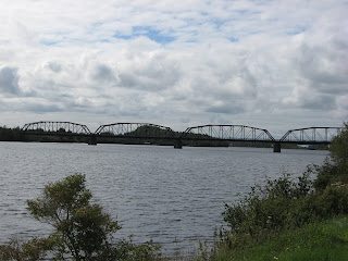 Newfoundland. Since we had an absolutely gorgeous, sunny, wind-free day, it was a nice deviation to walk across it and look at the peaceful, flowing river.
 On the way back, we spotted this unusual decorated tree. You never know who is watching you.

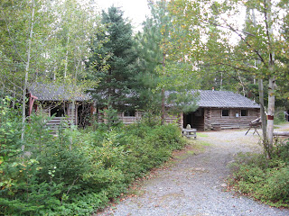 It would have normally housed 25-30 men who worked cutting timber for paper mills. They normally were paid $.90 per cord of wood and the normal logger could cut an average of two cords a day. As if this wasn’t bad enough, they had to pay $25.00 a month out of their pay for room and board. For this they received three meals a day and a wooden bunk. They would chop fir boughs to lay on top of the bunks to help keep them warm and reduce the hardness of the wood.
 Many of them were fishermen looking for extra money to feed their families and might have walked for days before arriving at the camp, hoping to get hired. They worked long days in boggy, wet land, with very strict rules to live by. Sometimes there were two men to a bunk, but always they had their fill of food, However they were not allowed to talk in the dining room at meal time in order to facilitate getting everyone served quickly.
 The times were hard, the pay was poor but to many, it was the only chance their family, which they had left back at home, had at surviving. In later years, the logging companies built the company town of Grand Falls and many of the loggers brought their families to live here where the company provided a school for the children, a store for supplies, and homes for the workers. If you did not work for the logging company, you could not live in the town of Grand Falls, so those who were not working for the logging company, settled outside the city and that area became knows as Windsor. Gradually both towns joined together as one and as the introduction of power saws meant fewer men could cut more wood, companies employed smaller workforces and the logging industry declined.