The next morning found us heading down the Fundy Coastal Drive in New Brunswick. There was a small area of the Province that we had missed when we came thru originally and we wanted to catch it on the way out.
It was a windy, drizzly day but we decided to drive up to Moncton, New Brunswick to experience Magnetic Hill. We were able to drive our truck and fifth-wheel to the foot of the hill, shift the truck into neutral, and sat tight while we coasted uphill on Mountain Road. It was quite an experience but we must admit that the magnetic hill that we enjoyed with Betty and Al, was just as good, if not better. Is it really magnetic, or magic?
McKenzie, George and I got out to look around a bit though most of the shops were already closed for the season. McKenzie enjoyed sitting in one of the chairs in the outside restaurant and seemed disappointed when no one brought her any treats.
From there, we drove over to the Hopewell Rocks for a chance to walk on the ocean floor! When we arrived, it was almost high tide and the water was coming in so we just walked around and looked a bit. Although the flower pot rocks come in a variety of different shapes and sizes, they have all been formed over millions of years by the dynamic movements of the earth and erosion from glaciers, tides, snow, ice and winds. The story of the rocks began approximately 300 million years ago when fast-flowing streams deposited thick layers of sand and gravel at Hopewell Cape from nearby Caledonia Mountains. Over time the sand and gravel compacted into layers of conglomerate rock and sandstone. Forces within the earth thrust and tilted the rock layers, creating large vertical and horizontal fractures. From this point on the flower pots began to evolve into their unique shapes. We took a few pictures of the flower pots while the tide was in. The ranger told us that once the tide is completely in, there would be just enough room to kayak under the Lover’s Arch.
Imagine 100 billion tons of water moving in and out of a bay twice every 25 hours. Powered by the gravitational pull of the moon and sun, Fundy’s tides are among the highest in the world and vary daily with the changing positions of these celestial bodies. Because the Bay of Fundy is funnel shaped – wide and deep at one end and shallow at the other, tides are pushed increasingly higher as they move up the Bay. By the time they reach “the Rocks”, the tides are over four stories high.
Big Cove and Castle Rock boast two of Hopewell’s largest and most interesting sea caves. The vertical cliffs in this area are nearly 100 feet high.
When we came back the next day at low tide, we were able to walk down on the ocean floor and look closely at the flower pots and caves.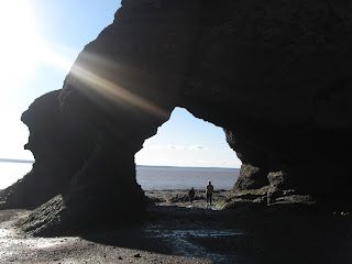 We had a window of approximately three hours to do our looking before the water returned. It was very amazing to sit on the rocks and watch the tide start coming back in.
 Also, a lot of fun to walk around and look at all the different carved formations.
The Bay of Fundy is a refueling stop for thousands of sandpipers on their trip south. In late summer, thousands fly from their nesting sites in the Artic. Each shorebird stops to rest and gorge constantly for about two weeks during early to mid August. From “the Rocks” the Sandpipers will fly three days and four nights non-stop to their winter home on the northern coast of South America. During their stopover, they will eat enough mud shrimp which live in the nutrient rich mud flats, to double their weight. The extra fat gives them the energy to complete their journey.
The next morning found us at Saint John, New Brunswick. We had wanted to go the City Market which houses Canada’s oldest continuing farmers’ market. The roof of the building was built like a ship's inverted hull and inside has colorful stalls displaying local produce, meat, seafood, and just about anything you want to eat. It was fun to walk thru all the displays. Once we were finished there, we walked down to the old cemetery which was established shortly after the landing of the United Empire Loyalists in 1783.
Our final stop in New Brunswick was at the Reversing Falls. Once again, we saw it at low tide and again at high tide. As the tide in Saint John Harbor rises, the downward flow in the St. John River slows and stops. The push of the Bay’s tides continues to high tide, causing the river to create rapids upstream. This happens twice in 24 hours.
 We have to say that this was a big disappointment. I thought we were actually going to see waterfalls reverse themselves, but it was just small rapids in the water. So, if you are short on time and need to skip something, this would probably be a good one.
We left and drove through the small villages of St. George and St. Martins and on to St. Stephen where we crossed the border into Maine. The border crossing was pretty uneventful this time. They had us pull our rig into a huge garage and x-rayed it and we were on our way. It is good to be back in the old US of A. Now we have to get reoriented to all the things we have been missing these past four months such as television, internet, US currency, etc. We thoroughly enjoyed our Canada tour this summer and can’t say enough good things about Newfoundland, but it is always nice to get back to family and friends. We’re arriving in Maine just at the fall foliage time so hopefully, we’ll be able to get some good pictures to share with you as we travel around the New England area. Love and hugs to all of you!!
It was a windy, drizzly day but we decided to drive up to Moncton, New Brunswick to experience Magnetic Hill. We were able to drive our truck and fifth-wheel to the foot of the hill, shift the truck into neutral, and sat tight while we coasted uphill on Mountain Road.
It was quite an experience but we must admit that the magnetic hill that we enjoyed with Betty and Al, was just as good, if not better. Is it really magnetic, or magic?McKenzie, George and I got out to look around a bit though most of the shops were already closed for the season.
McKenzie enjoyed sitting in one of the chairs in the outside restaurant and seemed disappointed when no one brought her any treats. From there, we drove over to the Hopewell Rocks for a chance to walk on the ocean floor! When we arrived, it was almost high tide and the water was coming in so we just walked around and looked a bit. Although the flower pot rocks come in a variety of different shapes and sizes, they have all been formed over millions of years by the dynamic movements of the earth and erosion from glaciers, tides, snow, ice and winds. The story of the rocks began approximately 300 million years ago when fast-flowing streams deposited thick layers of sand and gravel at Hopewell Cape from nearby Caledonia Mountains. Over time the sand and gravel compacted into layers of conglomerate rock and sandstone. Forces within the earth thrust and tilted the rock layers, creating large vertical and horizontal fractures. From this point on the flower pots began to evolve into their unique shapes. We took a few pictures of the flower pots while the tide was in. The ranger told us that once the tide is completely in, there would be just enough room to kayak under the Lover’s Arch.
Imagine 100 billion tons of water moving in and out of a bay twice every 25 hours. Powered by the gravitational pull of the moon and sun, Fundy’s tides are among the highest in the world and vary daily with the changing positions of these celestial bodies. Because the Bay of Fundy is funnel shaped – wide and deep at one end and shallow at the other, tides are pushed increasingly higher as they move up the Bay. By the time they reach “the Rocks”, the tides are over four stories high.
Big Cove and Castle Rock boast two of Hopewell’s largest and most interesting sea caves. The vertical cliffs in this area are nearly 100 feet high.
When we came back the next day at low tide, we were able to walk down on the ocean floor and look closely at the flower pots and caves.
We had a window of approximately three hours to do our looking before the water returned. It was very amazing to sit on the rocks and watch the tide start coming back in. Also, a lot of fun to walk around and look at all the different carved formations. The Bay of Fundy is a refueling stop for thousands of sandpipers on their trip south. In late summer, thousands fly from their nesting sites in the Artic. Each shorebird stops to rest and gorge constantly for about two weeks during early to mid August. From “the Rocks” the Sandpipers will fly three days and four nights non-stop to their winter home on the northern coast of South America. During their stopover, they will eat enough mud shrimp which live in the nutrient rich mud flats,
to double their weight. The extra fat gives them the energy to complete their journey.The next morning found us at Saint John, New Brunswick. We had wanted to go the City Market which houses Canada’s oldest continuing farmers’ market.
The roof of the building was built like a ship's inverted hull and inside has colorful stalls displaying local produce, meat, seafood, and just about anything you want to eat. It was fun to walk thru all the displays. Once we were finished there, we walked down to the old cemetery which was established shortly after the landing of the United Empire Loyalists in 1783. Our final stop in New Brunswick was at the Reversing Falls.
Once again, we saw it at low tide and again at high tide. As the tide in Saint John Harbor rises, the downward flow in the St. John River slows and stops. The push of the Bay’s tides continues to high tide, causing the river to create rapids upstream. This happens twice in 24 hours. We have to say that this was a big disappointment. I thought we were actually going to see waterfalls reverse themselves, but it was just small rapids in the water. So, if you are short on time and need to skip something, this would probably be a good one.We left and drove through the small villages of St. George and St. Martins and on to St. Stephen where we crossed the border into Maine. The border crossing was pretty uneventful this time. They had us pull our rig into a huge garage and x-rayed it and we were on our way. It is good to be back in the old US of A. Now we have to get reoriented to all the things we have been missing these past four months such as television, internet, US currency, etc. We thoroughly enjoyed our Canada tour this summer and can’t say enough good things about Newfoundland, but it is always nice to get back to family and friends. We’re arriving in Maine just at the fall foliage time so hopefully, we’ll be able to get some good pictures to share with you as we travel around the New England area. Love and hugs to all of you!!
No comments:
Post a Comment